New satellite ‘Sentinel-1’ captures large floods in Namibia
On 3 April 2014, the European environmental satellite Sentinel-1 was launched. In just 10 days on 13 April the satellite tuned in over Namibia to capture the extent of flooding on the Caprivi plain from the Zambezi River.
On 3 April 2014, the European environmental satellite Sentinel-1 was launched. In just 10 days on 13 April the satellite tuned in over Namibia to capture the extent of flooding on the Caprivi plain from the Zambezi River. Since the radar sensor has all-weather capability and a wide swath acquisition mode, Sentinel-1 can capture large floods in spite of bad weather and cloudy conditions.
The image from Sentinel-1 was converted into a flood map and 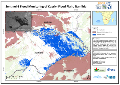 shared with the Namibian authorities to help them assess the situation better and make timely decisions. This was done using the Water Observation and Information System (WOIS) developed by DHI GRAS and their partners under the European Space Agency’s (ESA) TIGER-NET project. The information provided could also be used to complement hydrological modelling based on the exact mapping of the flood extent from satellite.
Apart from monitoring of floods Sentinel-1 is also poised to acquire timely image data for other monitoring and emergency tasks including the mapping of sea-ice conditions and tracking the paths of oil slicks and other polluters. Sentinel-1 is also highly relevant for other environmental modelling applications through its operational capacity for land monitoring of forests, water, soil and agriculture.
Read more