The results of the model closely match the measured wave heights.
On 11 April 2012 at 2:38 pm local time an earthquake of the magnitude Mw=8.6 occurred 500km off the north-western coast of Sumatra in a depth of approximately 22 km - near the region where 2004 the devastating Indian Ocean tsunami was generated, which caused more than 230,000 fatalities. The earthquake was felt strongly in Sumatra, but also in Malaysia, Singapore and faraway places like Bangladesh and the Maldives.
Awareness has been high this time. Seven minutes after the earthquake, a Tsunami watch has been set into effect for countries across the Indian Ocean, including Indonesia, Sri Lanka, Australia, Kenya, South Africa and Singapore. A tsunami warning has been issued for the whole Indian Ocean.
Fortunately, no big tsunami was generated by the recent earthquake. The reason lies in the tectonics: This earthquake occurred further away from the subduction zone. While in 2004 the plates slit quickly in vertical direction against each other (dip-slip mechanism in subduction zone), this time there was a more horizontal movement in the ruptured area (intra-plate strike-slip mechanism). Such movements cause deformations of the ocean bottom, which have to be estimated in a tsunami model.
At DHI, we ran a MIKE 21 HD model of the mini-tsunami, which used data available within the first minutes after the earthquake (USGS, 2012). The earthquake posed a special challenge: No proper rupture estimations exist for strike-slip earthquakes of this magnitude. Using relations for smaller earthquakes would, however, considerably overestimate the tsunami wave. Therefore, we estimated the rupture dimensions using relations for subduction zone earthquakes (like the one in 2004) to calculate the initial water surface elevations in the model.
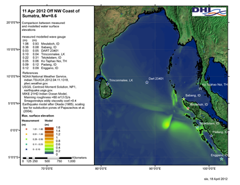
Calculated water levels have been compared with all gauge measurements which have been available in the modeled area (PTWC, 2012). The results of our model closely match the measured wave heights. At the location of the highest wave record, which was in Meulaboh (Aceh Province) on Sumatras western coast, the highest water level has been underestimated by only 12%. Especially under the condition that only data has been used which was available within the first minutes after the event, the results match measured wave heights very well.
A high-precision tsunami model is important e.g. in the preparation of hazard maps, construction of a Tsunami warning system and similar measures of disaster management.
References:
PTWC, 2012. Message indian.TSUIOX.2012.04.11.1318. NOAA's National Weather Service.
USGS, 2012. Magnitude 8.6 - Off the West Coast of Northern Sumatra. USGS.