Assessing riverbank and coastal erosion processes in Mozambique
We helped NIRAS provide the Government of Mozambique with a detailed coastal analysis of the Macaneta Peninsula, with the support of the Danish International Development Agency (DANIDA).
 We helped NIRAS provide the Government of Mozambique with a detailed coastal analysis of the Macaneta Peninsula, with the support of the Danish International Development Agency (DANIDA).
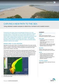
The Macaneta Peninsula protects the Lower Incomati Estuary in Mozambique from the Indian Ocean. Riverbank erosion in recent years has caused concern that the river could break through a narrow isthmus, threatening the fishing and agriculture industries in the area.
To determine whether protection measures were needed, the Government of Mozambique needed to know the:
- extent and rate of the erosion
- factors causing the observed erosion
We worked with NIRAS to perform a detailed coastal erosion study of the Macaneta Peninsula. Our analysis showed that the dynamics of the river and the sea seem to have reached a balanced state that maintains the isthmus. As such, the river is unlikely to break through the isthmus. If a breakthrough were to occur, it would likely be due to an extreme wave and water level event, such as a storm with surges and large waves.
With this information, Mozambique now has a better understanding of the:
- general processes acting on the Macaneta coast
- processes that could cause the Incomati River to break through the isthmus
- possible consequences of such a breakthrough
This will enable the Mozambican government to carefully weigh their options in the future.
Read more