The recently completed mid-term review of TIGER-NET marks a major milestone for the project, in which we – in collaboration with our partners – successfully developed an Earth Observation (EO)-based Water Observation and Information System (WOIS). This system was implemented in selected African water authorities, thereby ensuring continued EO support delivery for African Water Resource Management.
In spring 2012, the TIGER-NET project was launched as a major three-year component of the TIGER initiative of the European Space Agency (ESA). The main goal of the TIGER project is to support the African EO capacity for water resource monitoring. The aim of TIGER-NET specifically is to build capacity for water resources monitoring based on EO technologies at selected African water authorities. This is done through the development of an open source WOIS that integrates satellite information for the monitoring, assessment and inventory of water resources.
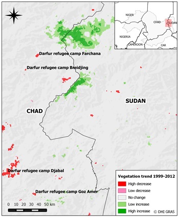
TIGER-NET product example: Land degradation in Eastern Chad caused by the war in Sudan’s Darfur region. Since 2003, over 3000 villages have been destroyed, and hundreds of thousands of people have been displaced into refugee camps in neighboring Chad. These areas are clearly visible in satellite data as growing camp sites and use of natural resources have caused a vegetation decline. On the other hand, the Sudan side shows signs of vegetation greening caused by agricultural land abandonment as forced by the population displacement. |
In partnership with Austrian-based company GeoVille and the Technical Universities in Vienna (TU-WIEN) and Copenhagen (DTU-ENV), we successfully developed the WOIS and implemented the system in five African water authorities:
- Lake Chad Basin Commission
- Nile Basin Initiative
- Volta Basin Authority
- Department of Water Affairs of Namibia
- Department of Water Affairs of South Africa
Moreover, the operational and practical use of the WOIS to support decision making has been demonstrated via a series of user-specific demonstration cases covering a wide range of themes and information products. These include:
- lake water quality
- flood monitoring
- land degradation and land cover characterisation
- water bodies mapping
- hydrological modelling
By providing this licence-free, powerful and extendable system, we look forward to the second cycle of TIGER-NET. In this phase, the user base will be expanded and the WOIS development and consolidation will continue. This will be done in order to accommodate the latest software developments and to provide adaptations for continued user requirements. It will also particularly focus on ensuring the support and development of processing capacity for the upcoming Sentinel satellite systems which will turn the WOIS into a fully operational monitoring system.
For more information on monitoring and managing Africa’s water resources with EO data, please visit:
http://www.esa.int/Our_Activities/Observing_the_Earth/Monitoring_and_managing_Africa_s_water_resources