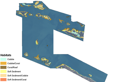
DHI GRAS successfully mapped submerged habitats in Cone Bay, Australia for the Department of Fisheries. This was done using state-of-the-art bathymetric mapping and water column correction methods in conjunction with object-based image analysis.
The work was done in collaboration with DHI Australia. They are supporting the Department of Fisheries in the development of an aquaculture production zone in Cone Bay, Kimberley (Northwest Australia), using a combination of modelling, remote sensing and
in-situ sampling.
The habitat map was useful in creating a baseline understanding of the hydrodynamics and marine biology of the bay. The output of the analysis was GIS files containing substrates classified into easy-to-use classes. It also comprised the very high resolution WorldView-2 satellite data that the analysis was based on.
The combined in-situ and satellite data formed the basis for building an integrated hydrodynamic and ecological model. The model was then used to assess the potential impact on sensitive marine habitats such as corals.
DHI GRAS has an extensive track record of delivering satellite-based information about water quality and marine habitats in relation to aquaculture production. For instance, daily information about potential algal blooms can be obtained through our near real-time monitoring systems.
For further information, please contact us at
gras@dhi-gras.com.