How we use Tropical Rainfall Measuring Mission (TRMM) data to depict the dramatic floods currently hitting Assam, India
During the last month, monsoonal rains killed dozens and left half a million homeless in the north-eastern Indian state of Assam. While annual floods are typical for this region, this year’s floods hit especially hard. Besides the immediate human and economic losses, the rains devastated nearly 400,000 hectares of farmland just near the end of the growing season.
We have looked in the regional rainfall to assess the severity of the situation. Based on TRMM satellite data, we estimated that the Assam valley area has received more than 450mm of precipitation in only a few days, causing extensive flooding.
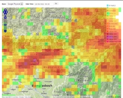
According to the Indian Meteorological Department (IMD), the normal accumulated precipitation for the whole monsoon season (June till September) is around 1800mm. That means that Assam has received almost a third of its total monsoon rains in only five days.
TRMM data can provide a very reliable measure of regional rainfall. For example, we use TRMM to provide an online real-time monitoring of weather events in the Philippines, forming the base of a weather indexed insurance product to protect microfinance providers against natural catastrophes. Don’t hesitate to get in touch if 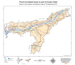 you are interested in our services.
The TRMM mission
The TRMM is a joint mission between National Aeronautics and Space Administration (NASA) and the Japanese Aerospace Exploration Agency (JAXA), dedicated to monitor rainfall in the tropics through microwave and visible infrared sensors, including the first space-borne rain radar. By use of a low-altitude orbit (350km), TRMM's complement of state-of-the-art instruments provide more accurate measurements focused primarily on heavy to moderate rain over tropical and subtropical regions.
TRMM measures precipitation on a three-hour basis and has a resolution of 0.25° latitude-longitude, which approximately corresponds to squares of 27x27km at low latitudes. With such a dense coverage, both in time and space, the widely recognized TRMM is currently the best option for monitoring and assessing rainfall in the tropics.
Top image: 24 hour accumulated precipitation (example from September 19, 2012) captured by the TRMM satellite and processed by DHI.
Bottom image: Inundated areas in the region on September 19, 2012 (Source: National Remote Sensing Centre, NRSC).