Satellite-based monitoring of freshwater lakes in Denmark
A beta-version of a web-based tool – developed by DHI GRAS, DHI and Aarhus University – for monitoring the ecological status of freshwater lakes in Denmark has just been handed over to the Danish Ministry of Environment. This concludes the development phases initiated in 2010 and leads the way for implementation in the monitoring programme for future use.
The collaboration was initiated in 2010 with the aim to explore the possibility of incorporating satellite data into the existing Danish lake monitoring programme. For this purpose, a beta-version of a water management tool has been developed, presenting satellite images and satellite-based chlorophyll data together with traditional survey information. Current monitoring of water quality builds solely upon traditional water bottle sampling, but only approximately 15% of the more than 600 larger lakes in Denmark can be annually covered with this approach. Satellite information can substantially expand the conventional monitoring – in space and time.
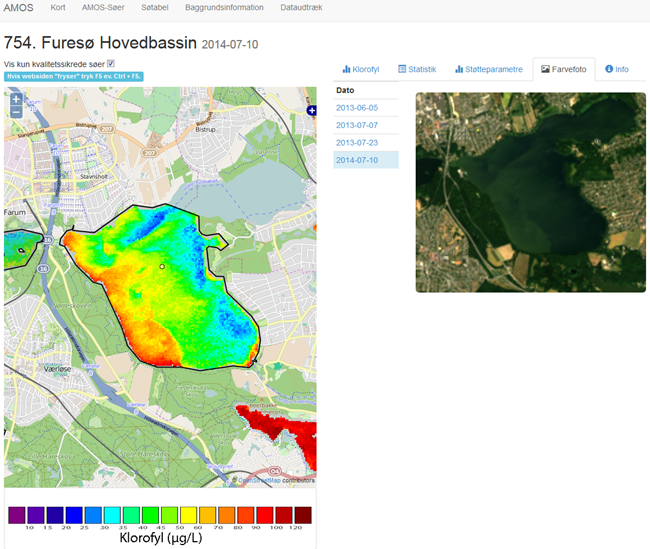 |
User interface of the (beta-version) satellite based water management tool. The distribution of surface chlorophyll-a concentration on 10 July 2014 for the main basin of Furesø is shown on the left. The map illustrates well the unequally distributed concentrations on that day due to easterly winds. This kind of variation cannot be captured with traditional sampling methods. The dot in the lake marks the location of in-situ sampling. The Landsat 8 image from which chlorophyll concentration was derived is shown on the right.
|
The freely available Landsat 8 satellite data was used in the tool to map chlorophyll concentration for all larger Danish lakes between April and October for 2013 and 2014. Satellite-based monitoring offers us the horizontal variation of chlorophyll within a lake, as well as occurrences of algal blooms both on a spatial and a temporal scale. If a status change becomes apparent from satellite data, the authorities can take actions, for instance, by re-establishing regular sampling.
With the launch of Europe’s Sentinel-2 satellite on 23 June 2015, new high-resolution data will soon become freely available. The data will certainly improve the quality of satellite-derived chlorophyll data for lakes. The beta-version of the tool presented here was customised for Danish conditions, but the approach can be implemented for any location worldwide.
This project was made possible with funding from the Eco-innovation sector of the Danish Ministry of Environment.
Read more