The Zambezi river basin experiences a number of natural disasters with floods being the most devastating. There is great need to reduce and manage the risk of the effects of such natural disasters, because they leave a trail of destruction that disrupts peoples’ livelihood and the economic growth in the basin and the southern African region as a whole.
It is for this reason that the floods in Malawi and Mozambique are being monitored closely by the newly established permanent Zambezi Watercourse Commission (ZAMCOM) Secretariat. The monitoring is done through the use of the Water Observation and Information System (WOIS), where free radar satellite images from the Copernicus Sentinel-1 mission are being converted into maps which show the development and current extent of the floods.
The WOIS is an open source software tool developed by DHI GRAS and partners under the TIGER-NET project funded by the European Space Agency, with the main goal of supporting satellite-based assessment and monitoring of water resources in Africa.
The information gathered is important to better assess the flood situation in the development of an operational flood forecasting tool for the organisation. With this system, ZAMCOM will be able to predict water levels and possible floods in advance using state-of-the-art modelling tools.
As Professor Zeb Phiri, the Executive Secretary of the ZAMCOM Secretariat explains: ‘Disaster risk reduction and management is a cornerstone of the ZAMCOM agreement. The flood maps derived from WOIS is an important contribution towards the current enhancement of the Zambezi Water Information System (ZAMWIS) and the implementation of a fully operational Decision Support System for flood forecasting and early warning in the Zambezi river basin’.
In Malawi, heavy rainfall returned over the weekend and the space-based monitoring of the flood situation will therefore continue over the coming days and weeks. Radar satellite images allow the following of flooding events independent of weather and clouds, which is why the open and free data of the Sentinel-1 mission is essential to water authorities for their monitoring purposes.
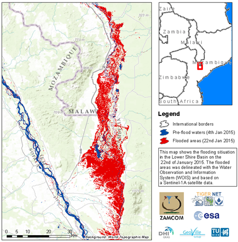
The flooding situation in the Lower Shire Basin on 22 January 2015. The flooded areas were delineated with WOIS based on Sentinel-1A satellite data.